"We’ll do the north in the morning and Le Morne in the afternoon." I have heard that sentence dozens of times, and it almost always ends the same way: arriving at four, the light going, and the feeling of having spent the day in the car. Mauritius is sixty-five kilometres long, which creates the illusion that everything is close — when a coast road, one village and two roundabouts are enough to turn thirty kilometres into an hour. That gap is what the map’s road trip mode corrects.
Budget tip: in Mauritius, part of your activities can cost you less. See how to save money with discounts on your activities.
I live in Mauritius and I built Moris Insider, the island’s guide and map. This article covers one single feature: the timed road trip — how it calculates, how it fills the planner, and what it cannot do.
Why everyone gets the distances wrong here
On a map the island looks tiny. In the car it stops being tiny at once. There is one motorway, it crosses the middle, and everything else is coast road: villages, speed bumps, buses pulling over, cane lorries in season. The same distance does not cost the same time depending on whether you follow the lagoon or cut across the plains.
Full guide: Renting a Car in Mauritius: Tips & Pitfalls to Avoid
The outcome is the badly built day: three places planned, two visited, and the third reduced to a photo from the car park because it is already five o’clock. It is not a problem of appetite, it is a problem of arithmetic — and a machine does arithmetic better than we do, especially on holiday.
What I actually do
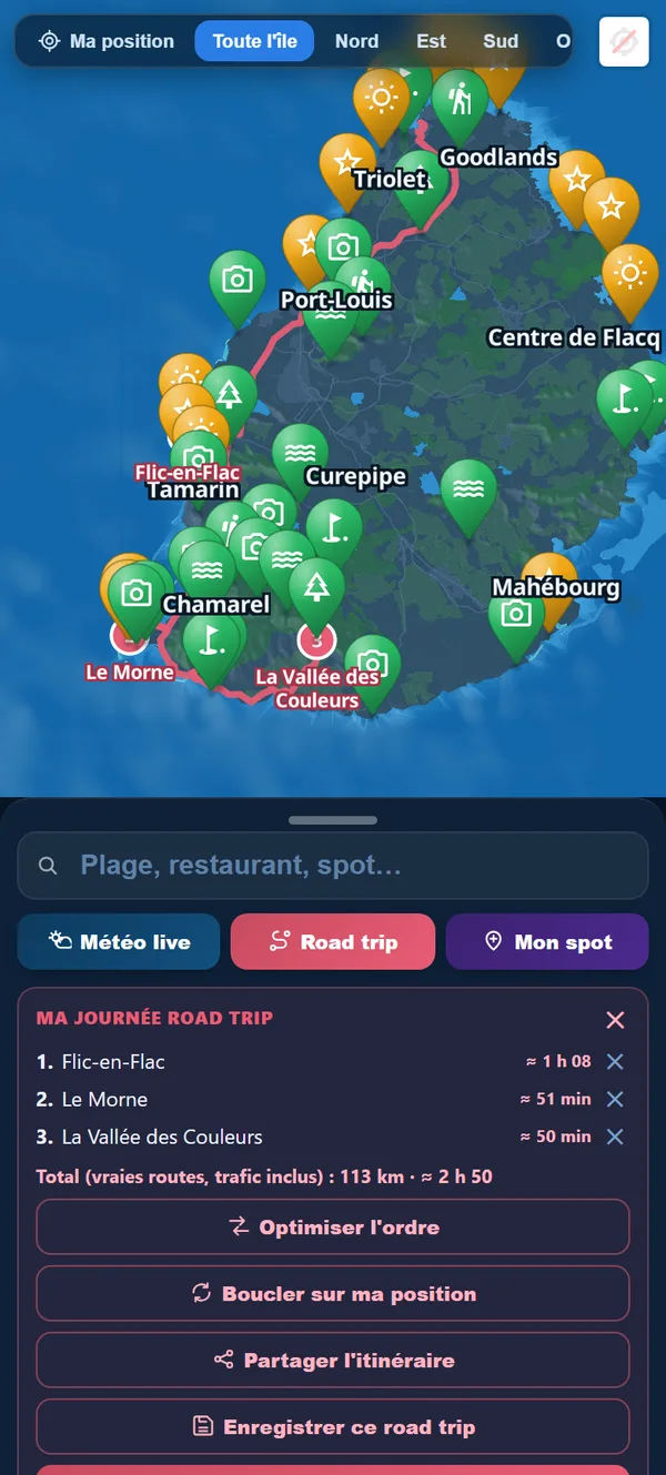
I open the map, switch on Road trip, and tap the places I want. Nothing else: in road trip mode a tap adds the stop and closes the preview, so you never wonder whether the place was taken.
The "My road trip day" panel fills up as you go, and it does all the work. On my last outing it showed this — four stops, north to south-east:
- Trou aux Biches — ≈ 5 min (from where I was)
- Cap Malheureux — ≈ 20 min
- Belle Mare — ≈ 58 min
- Blue Bay — ≈ 1 h 23
And, in bold under the list: "Total (real roads, traffic included): 97 km · ≈ 2 h 47". That is the number that settles things. Two hours forty-seven of driving in one day is not nothing: it leaves room to see four places properly, not six.
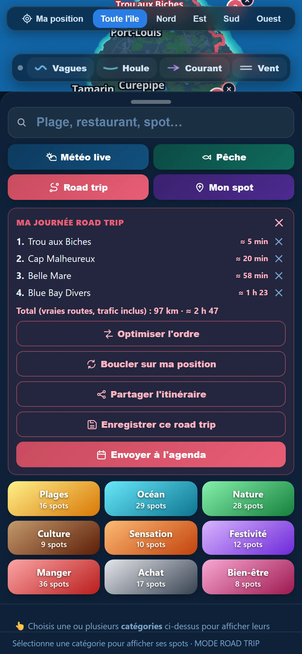
Under the list, five actions: optimise the order (from three stops), loop back to my position to return to the start, share the route as a link, save it under a name (from two stops), and send it to the planner. Saved routes are filed per destination, each with its own colour, and show one at a time so the map never turns into a plate of spaghetti.
Real roads, not a ruler on a map
The feature itself, plainly: with each stop added, the app asks a road routing service for the route and gets back the real line — the one that follows the bends of the coast and goes around the mountains. That is the line you see drawn on the map, and it is where the times come from.
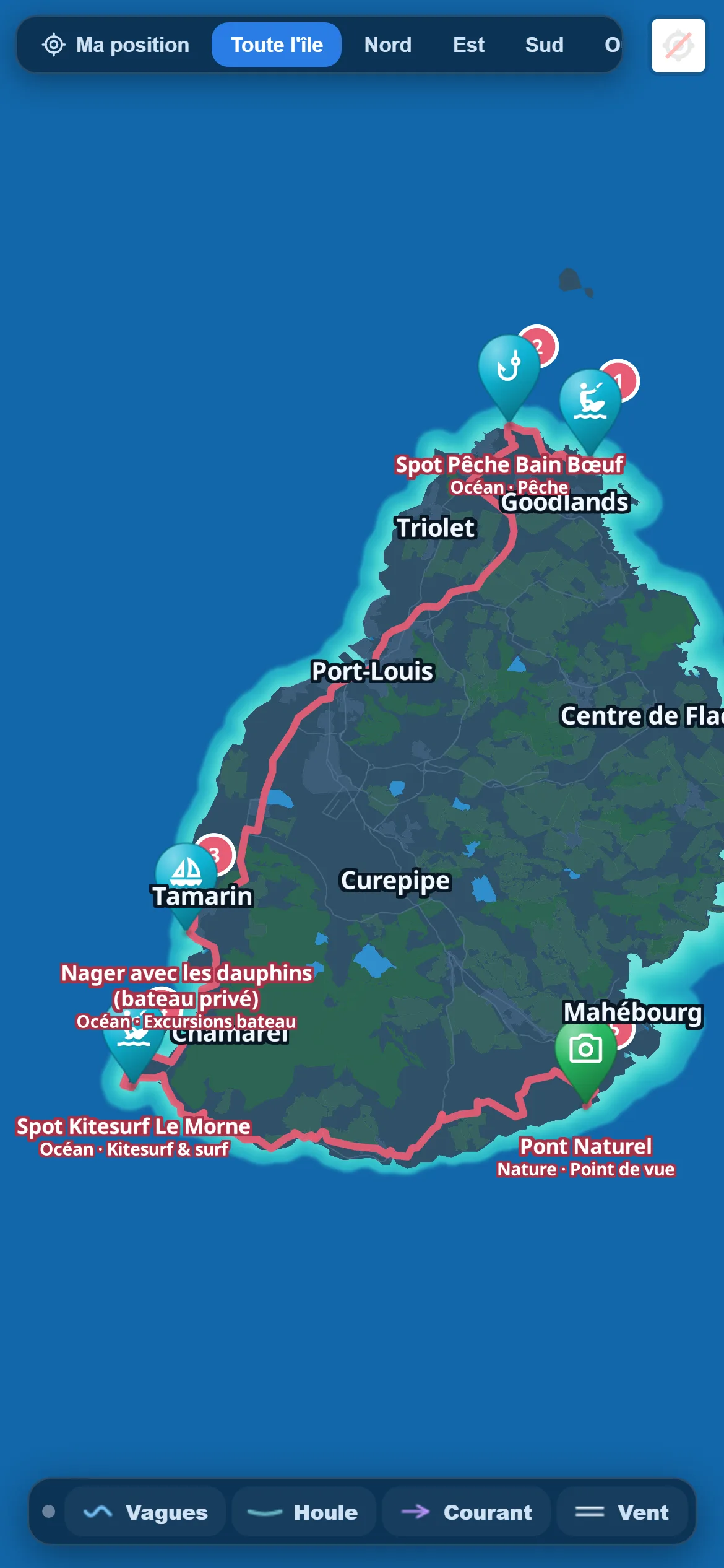
The advantage: the number on screen is comparable to the one your usual navigation app would give, because it comes from the same family of calculation. The benefit arrives at the moment of choosing: when "2 h 47" appears before you set off, you drop a stop of your own accord. Nobody likes being told no; everybody accepts a number.
And when the routing service does not answer — it happens — the app does not invent a plausible figure: it falls back on a cautious estimate, straight line at thirty kilometres per hour. That is deliberately pessimistic on fast roads and honest on small ones. An admitted approximation beats false precision. The places themselves are picked beforehand from the app’s categories.
Work your day out before you leave
The map and its real distances are in the app. €24.90 once, for life. 30-day money-back guarantee.
Discover the app →And the day lands in the planner, with its times
This is my favourite part, because it is where a calculation turns into a real day. The "Send to planner" button asks for the day, then writes each stop with its time.
The rule is simple, and I give it in full so there is no surprise: start at 9 am, then for each stop an hour and a half on site, plus the real driving time to the next one. If a leg could not be calculated, the app allows thirty minutes. And the day is capped at 8 pm: beyond that it does not push stops into the night.
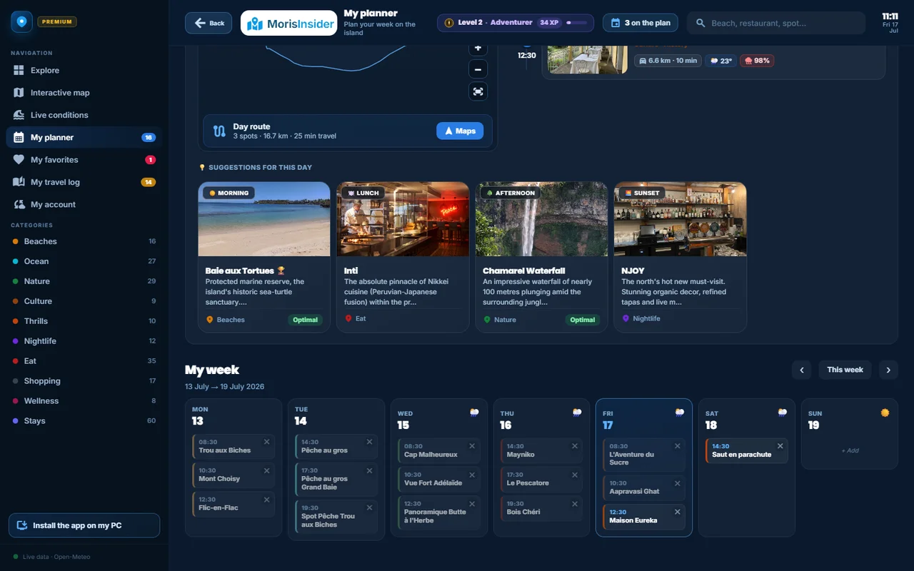
In practice my four stops become slots in the "My week" planner, next to whatever was already there. It stops being a wish list: it is a day, with times, that you can look at the evening before.
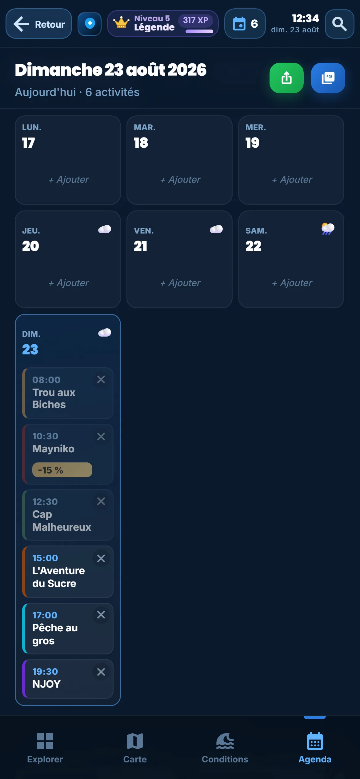
There is a follow-on to this, and it happens by itself: once a stop’s time has passed, it leaves the planner and moves into the travel journal. In other words, the day worked out in the morning becomes, by the evening, a list of what you actually did — filed by day and ready for a rating and a couple of photos. You plan once, and the record builds itself without retyping anything.
A word on one detail that mattered: until early August, routes were saved without their destination. A road trip built in Mauritius reappeared on another island’s map. It is fixed — each route now belongs to its destination — but I mention it because it is the kind of fault you only see with two destinations open at once. The places you set aside while scouting stay in your favourites.
The places you set aside while scouting stay filed in your favourites: in the morning you open your list instead of running the search again, and every stop kept is one tap saved on the map.
What the road trip cannot do
This is the part I care most about writing, because it prevents unpleasant surprises on the day.
An hour and a half per stop, whatever the stop. That is the most visible limit: a beach where you would stay all afternoon and a viewpoint where you spend ten minutes get the same allowance. The times are a frame, not a prediction — adjust them in the planner, it takes seconds.
The day stops at 8 pm. Load too many stops and the last ones bunch up against that ceiling instead of spilling into the night. It is a guard rail, not a calculation: when it happens, the day was too ambitious.
Points you drop yourself do not go into the planner. They count in the route and in the distances, but they create no slot — the app says so at the moment of sending, rather than making them vanish quietly.
And building a route is part of the app. If you are planning a first trip and want a week-shaped frame first, our 7-day Mauritius itinerary answers that question, and the road trip then sharpens each day.
A day that holds together
Real distances, calculated times, straight into the planner. Building a route is part of the app: €24.90 once, for life.
Discover the app →